
 |
| Looking closely in this photo, there are two National Guards with rifles manning the access to the lava flow, preventing curiosity seekers from nearing the flow. As we slowed to take this photo, they waved at us to get moving along. |
Yesterday morning, we headed to the Pahoa Community Pool to check it out for our family’s arrival. We’d heard it was a huge, clean, and lifeguarded pool available to residents at no charge.
As is the case around the Hawaiian Islands not all streets are marked. Although we had good directions on my phone, there were of little use when there are no road signs. Somehow, we managed to find the community pool.
 |
| Further down this road, which is Apaa St., the road is closed after the lava had crossed the road weeks ago. Click this link for details and photos. |
However, during our bit of wandering around the area, we saw the road that was closed off for the lava flow and the National Guards maintaining watch to avoid curiosity seekers from entering the dangerous area. Much to our delight we were able to take these photos included today of the area that we found most interesting including the smoke in the sky from the lava, once we arrived at the Pahoa Community Center to check out the pool.
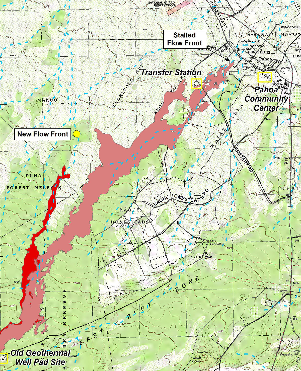 |
| Yesterday, we were at the Pahoa Community Center as shown on this map. We were able to see the smoke in the sky from the flow. In the next few days the city plans to allow visitors to see the lava from the Pahoa Transfer Station also shown on this map. |
We copied the above map this morning of the ongoing progress of the lava flow. Here’s a link to more information from the Hawaii County Civil Defense.
After checking out the pool (we weren’t allowed to take photos to protect the privacy of the few swimmers in the pool), we began the drive to Hilo to the Safeway store to buy groceries for our four family members arriving tomorrow.
 |
| Numerous power poles located in the path of the lava flow have been covered in fire retardant materials to prevent the flow from destroying the power to the area which has worked. |
Along the way, Tom spotted what looked like an interesting road which proved to be one of the most scenic roads on Big Island, the Red Road, Route 137. Go figure, how we ended up on that road. We couldn’t stop oohing and aahing along the way, stopping frequently to take photos which we’ll post tomorrow.
Here’s a link to the Red Road scenic drive.
 |
| The house in the background could easily fall prey to the lava should it continue on this path. |
After the amazing drive we found our way to Hilo without a map considering that its almost hard to get lost if one follows the coastline on an island. Of course, we always have our personal navigator on board, Tom Lyman, Mr. Sense of Direction, who hardly ever disappoints.
 |
| The Pahoa Community Pool. No photos were allowed inside so we shot this exterior photo. The pool is huge and will provide hours of fun for our family. |
The grocery store was a two hour, two cart, confusing ordeal. Buying foods others eat so different from our usual purchases, plus buying food for us, was quite a challenge. But I stayed “over bubbly” and much to my delight Tom wasn’t his usual “overly grumpy” while in a grocery store. He did well, stayed cheerful and we actually had a good time.
 |
| Behind this downed area of vegetation, lays the lava flow. Soon, we hope to see the actual flow when an area is opened to the public at the Pahoa Transfer Station. |
He brought everything inside when we returned “home” and I insisted on putting everything away. It didn’t appear there would be room for it all but, I managed to make space for everything in the small pantry and average sized refrigerator.
 |
| The smoke in the air from the lava flow. We could smell it as we stood in the parking lot of the Community Center. |
Once Tom and I move over to the house next door, we’ll be moving over the foods we usually eat making room for the foods in this house for the other two of our families. It will all work out, one way or another.
I haven’t decided yet if I’ll join Tom on the two hour drive to the Kona airport to pick up family tomorrow afternoon. I just may stay behind and prepare dinner, having it ready when they arrive.
 |
| There was a reddish tint closer to the ground as shown in his photo. During this period the sky was otherwise relatively clear. |
We’re waiting for the sun to peek through which looks hopeful after several days of clouds and rain. An hour of sunshine would serve us well.
Have a fabulous Friday!
Photo from one year ago today, December 5, 2013:
 |
| When Okee Dokee drove us to the grocery store in Komatipoort, we marveled at the wildlife in our neighborhood in the bush. A sight such as this was to be found daily. For details from that date, please click here. |